“Nerve centre of Corbett Estate operations”
Background
Duncrievie Road is named after the village of Duncrievie, which is in Perthshire, just off the M90. The village is a stone’s throw from Glenfarg – another Corbett street name – and both villages sit in the parish of Arngask, which is also name-checked on the Catford Estate. The area was important to Corbett because it’s where his younger brother Harry lived during the 1880s. Harry sadly died of tuberculosis in his late twenties.
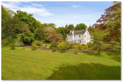
Duncrievie House, Glenfarg, Perthshire, Scotland
Duncrievie Road is one of the shortest on the Corbett Estate, but it’s an important one because it was the nerve-centre of operations when building started in the late 1890’s. Corbett himself would sometimes get the train from central London to Hither Green and call in at the Estate Office, located halfway up the road opposite the junction with Wellmeadow, for a progress report.
Building of houses on the road itself only started in 1910, when most of the rest of the Estate was already completed. The Estate Office was removed and 12 houses put up on the last piece of Corbett’s land to be developed. The 1911 census recorded just 37 people residing in the road, which equates to 4.1 people per house – a mid-range average on the Estate.
Not all the houses in the road are part of the Corbett Estate however. Only from Nos. 6 to 28 on the even side of the road were built on Corbett-owned land. The houses from No. 30 up to Hither Green Lane were built in or around 1928, many years after the Corbett Estate itself had been finished, which explains why they look quite different.
The Early Residents: details from the 1911 Census
Duncrievie had slightly fewer females as a percentage of residents than the Estate average, with 51.35% of the residents being women and girls, and 48.65% men or boys.
There were no multiple female adults sharing the same Christian names, but common names of the day such as Alice and Edith, Elsie and Winifred are represented. Amongst the men, there were two Thomas’s and two Williams, which was par for the course in this era. The most unusual first name was Deveraux, which belonged to Deveraux Aland, a 48 year-old ‘Sign and Glass Writer’ who lived at No. 26.
Perhaps unsurprisingly given its proximity to Hither Green Station, the most popular kind of work for the citizens of Duncrievie Road was on the railway – although in terms of numbers this was quite small. Of the 15 people in employment, 4 said that they did some sort of Railway work: there was William Stacey at No. 6, a ‘Railway Inspector Secretary’; Thomas Fitt at No. 24, a ‘Railway Traffic Inspector’; his son William Fitt, a ‘Railway Ticket Examiner’, and finally Albert Burton at No 26, a ‘Railway Guard’. Non-railway jobs included those of Jennie and Elsie Stacey, daughters of William, who were both shorthand typists; Seth Stubbins at No 14 who was a leather salesman; and Henry Ward at No. 10 who was a watch, clock and jewellery repairer.
The street record for the highest number of children in a single family was 4, which is quite low for the Estate. It was held by the Stacey family, who we’ve already heard a bit about, at No 6. In addition to William, Jennie and Elsie, there was Dorcas – William’s wife – and her eldest daughter Edith (29), plus Edith’s son Leslie (aged 2).
At number 14 lived Annie Stubbings who takes the road’s prize for ‘resident from furthest away’: She was from Mansfield, Nottinghamshire. Overall, the vast majority of the street’s residents (70%) had been born in London (a little lower than the Estate average of 72%).
The oldest residents at the time of the 1911 census were William Stacey at No. 6 and Emma Fitt at No. 24. They were both was 60 years old.
A farmhouse with a Corbett connection
There may not have been a single sale of land around Hither Green and Lee that had been more significant than the sale of North Park Farm by the Earl of St Germans in 1895 to Archibald Corbett. The sale allowed for the development of what was originally known as the St Germans estate, now of course generally known as the Corbett Estate.
The original farm buildings for North Park Farm itself had been demolished before Corbett arrived on the scene, but one of the two brothers who leased the farm, Samuel Sheppard, had built a new house nearby for his family in 1867. It was called Eliot Lodge, and it still stands today at the corner of Duncrievie and Hither Green Lane. Whilst the Estate was being built, it was home to Robert Pettigrew, Corbett’s agent for St Germans, who worked in the estate Office down the road.
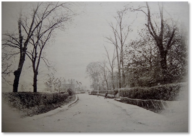
Eliot Lodge in the distance on the left c 1880
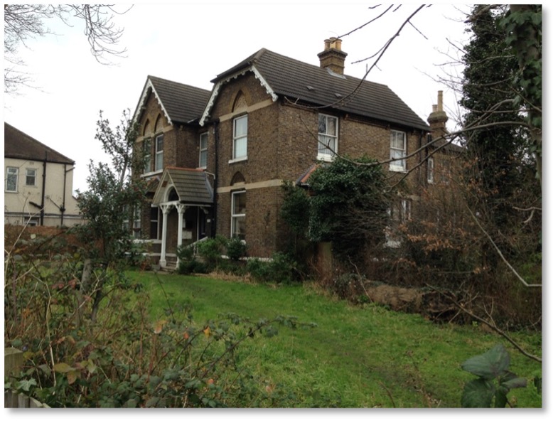
Eliot Lodge today – now No. 295 Hither Green lane
Sheppard also built a row of three farm labourers’ cottages a little further south in Hither Green Lane, near the junction with Brownhill Road, which survive today.
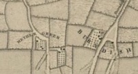
The name of North Park Farm may well have been in existence around the mid-16th century. It is possible that the location may have changed but in the following 1745 map – the easterly buildings below the Hether (Now Hither) Green lettering shows them situated at the end of what is now Duncrievie Road.
Initially it was a small, around 65 – 75 acres, and for a while it seems to have been known as Plum Farm. There had also been a South Park Farm too – of around 70 acres – centred around Dowanhill and Hazelbank Roads, which later moved to somewhere around the Torridon and Brownhill Roads junction. The South Park name lives on in a street, South Park Crescent, to the east of Verdant Lane. The farm seems to have been merged with North Park Farm by the mid 1800’s along with part of Rushey Green Farm and a former nursery called Butlers Gardens.
It was run by the Owen family for a generation and a half; and then by the Sheppard brothers – Samuel and Edward. We presume that eventually the land went up in value so much (with the coming of the railway), that it became less attractive for farming to the ultimate owner – the Earl of St Germans, who sold it to Archibald Corbett.
Queen Anne’s Bounty
At the other end of Duncrievie is Springbank Road and the corner building, now a shop is No.72 Springbank Road, but also included in the same title is No. 3 Duncrievie Road. This land was also purchased by Corbett, but he later sold it to ‘The Governors of the Bounty of Queen Anne for the Augmentation of the Maintenance of the Poor Clergy’.
The Queen Anne’s Bounty was a scheme established in 1704 to augment the incomes of the poorer clergy of the Church of England, and by extension the organisation administered the bounty and eventually numerous other forms of assistance to poor livings.
The bounty money was to be used to increase the income of livings yielding less than £80 a year. It was not paid directly to incumbents, but instead used to purchase land, the income from which augmented the living. The livings to be augmented were selected by lot from those with an annual income less than £10, or (in the early years of the bounty) those where augmentation by a third party was offered conditional upon augmentation by bounty funds.