“A street with missing houses”
Background
Hazelbank Road forms the southernmost boundary of the Corbett Estate. The name possibly comes from a small village on the Clyde, south east of Glasgow, which Corbett may have frequented.
The road runs uphill from east to west starting at Verdant Lane opposite Hither Green Cemetery and continues downhill towards Bellingham station as Bellingham Road. The houses were mainly constructed in 1901-1902 by a Scottish builder named James Watt, who also built many other houses, and quite a few cinemas, on land in the Lewisham area.
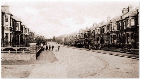
Hazelbank Road, seen from the corner of Minard Road, as shown on a postcard sent in 1905
Torridon Road Primary School stands on the corner of Hazelbank and Torridon Roads, one of two remaining schools that were built as an integral part of the estate. The other one is Sandhurst Road School.
The Early Residents: details from the 1911 Census
Census statistics show that there were 123 houses in the road with 542 people occupying them. 51% of these were female and 43% were children. The average number of children per family is 1.8 which is lower than in many other streets, though most of the other statistics are in line with the average for the estate.
The average number of people living in the houses is 4.4 which is consistent with the size of the houses here. Nos 26, 49 and 123 all had a total of 9 people living in them and Nos 26 and 49 each had 7 children, so although there were not as many children as in other roads, some of the families were large. There were also 8 lodgers, 12 live-in servants and 5 visitors recorded on the night of the census. 75% of people were born outside the current Greater London Area which is consistent with other roads on the estate, with most of the others coming from other parts of the UK. There were four people who were born abroad: one was a son who was born in India, one an adopted daughter born in Australia, one a lodger who was visiting from the USA and one adult was born in Bermuda – early evidence of the now thriving Caribbean presence on the Estate.
The most common names for adult women were Emily, Alice and Mary, and William and George for men. Gladys, Dorothy and Ivy were the most popular girls’ names and Stanley and Arthur for boys. In 33 families a child was named after their parent, and this applies to both boys and girls, a practise which was common at the time. The most unusual surname is Foggo, belonging to the family living at No. 90, a couple with two young sons. The oldest resident was Mrs Eleanor Lansdale McCarthy, a widow from Lancashire aged 86 who lived at No. 83 with her two single middle-aged daughters, both of whom were housekeepers.
Those who worked were largely in clerical jobs and trade. Clerks made up a large percentage and they worked in shipping, law, insurance, chemists and many other enterprises. Some people worked in printing, clothing, drapery, tailoring, hosiery, millinery as well as the civil service and teaching. They were butchers, bricklayers, carpenters, dairy workers, brass fitters and house painters. More unusual were two people who worked in the hop trade which was very important for the brewing industry but relatively rare in towns rather than the countryside: one was a Hop Examiner and the other a Hop Warehouse Superintendent.
Census anomalies: planning and house numbers
Hazelbank Road has a number of anomalies in the house numbering that lead us to speculate how the planning system that allocated the plot numbers operated. Although today the house numbers begin at No. 1, the census shows no returns for Nos 1 to 5. These houses are built as one block and are different in style from those at No. 9 onwards. But there are actually five houses, the first of which has no number, and the block includes No. 7, for which there is a census return, so it was not only built but also occupied at that time.
Further down the road, house Nos 32 to 38 are missing, and where they would have been is a plot of land between Wellmeadow and Hafton Roads which is used as allotments. Since no census returns were entered for these houses it seems likely that they were never built.
Most intriguing of all is the absence of house Nos 57 to 63. There is a gap here on which stand some garages, but the absence of census returns suggests that houses were never built on these plots. We know that many plots were sold on to developers and it may be that planning permission was never granted or that the builders did not develop them for other reasons.
Nos 151 to 155 do not exist either. The houses at 143 to 149 look as if they may have been built at a later date, but there are no census returns for any of the house numbers between 143 and 155, so they may not yet have been built in 1911.
It is interesting to note that there is no gap in the numbering in the houses either side of Torridon Road Primary School, which sits on the corner of Torridon Road. This is probably because the school was part of the original plan for the estate, like the Methodist Church and school in Hither Green Lane, and so the houses on either side are continuously numbered.